Plans go in for 167 new homes on farmland near Lancaster Leisure Park


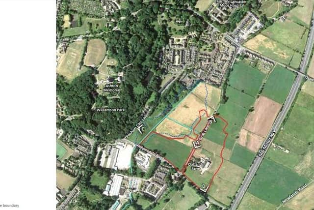
The total area of the site is 8.8 hectares and runs to the east and west of Grab Lane, which will remain a "rural lane" at the centre of the site, with trees and dry stone walls retained.
The application states that individual homes won't be accessed directly from Grab Lane, but via three primary access points, as well as five private drive connections.
Advertisement
Hide AdAdvertisement
Hide AdThe homes are a mix of detached, semi-detached, and terraced properties with 2-5 bedrooms, with 30 per cent "affordable housing" included.
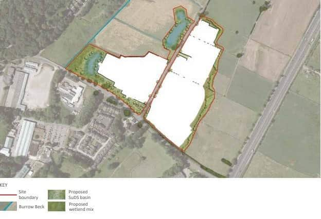
The proposals includes 2.28 hectares of public open space with an equipped children's play area, and 0.45 of attenuation ponds to mitigate flooding.
Burrow Beck runs to the west of the site, and concern has been raised in the past about flooding.
Story Homes said it had met with the South Lancaster Flood Action Group to discuss the matters, as well as the Lead Local Flood Authority and the Environment Agency.
Advertisement
Hide AdAdvertisement
Hide AdThe plan includes a Surface Water Drainage Strategy, which states:
"Surface water drainage has been designed in accordance with local policy.
"The proposed drainage has been designed to work with the existing landform, feeding towards the lowest parts of the site to the west and draining into the existing Burrow Beck.
"New attenuation areas will be provided in the western part of the site.
Advertisement
Hide AdAdvertisement
Hide Ad"These will act as dry basins for most of the year, holding water during times of extreme rainfall only, before slowly releasing the water into Burrow Beck.
"The attenuation areas will be located within the open space network, becoming a focal feature in views from Wyresdale Road and Grab Lane, and will further enhance the site's ecological, biodiversity and amenity value.
"The existing drainage ditches and respective easements running through the western part of the site are retained within the proposed development layout.
"A network of underground pipes underneath the proposed primary and secondary roads will convey surface water runoff into the ditches and attenuation area before being discharged."
Advertisement
Hide AdAdvertisement
Hide AdThe application also includes details on highways access and traffic movement.
The development will be accessed via Grab Lane, with three primary roads and five private drives proposed to take direct access from the route as it divides the site into two halves.
Grab Lane will have footways added to both sides in the vicinity of the site to provide safe and convenient access to existing footways along Wyredale Road.
Some existing dry stone walls will be removed and reconstructed at the back of the new footway along Grab Lane.
Advertisement
Hide AdAdvertisement
Hide AdPrimary vehicular routes extend from Grab Lane and ensure safe and viable access to all properties. Along this will be a series of nodes and focal buildings which will add interest to the street scene and create a sense of place.
The primary road corridor will include a 5.5m wide carriageway with 2m wide footpaths to either side.
Branching off from the primary road will be a series of secondary routes (4.8m wide with 2m wide footpaths to either side) and private drives (4.5m wide).
Private drives are designed to run alongside greenspaces, and housing will front onto them to provide natural surveillance and frame the space.
Story Homes said that overall it is considered that the site is well suited to residential development offering desirable new homes in a sustainable location on the eastern edge of Lancaster.